

Post-Sandy MidAtlantic Coast Ecological Damage Assessment
As we all experienced firsthand, Superstorm Sandy walloped the MidAtlantic shoreline and interior this past fall. The following week the Rutgers Center for Remote Sensing & Spatial Analysis (CRSSA) was asked by the American Littoral Society to assist in a rapid assessment of impacts to coastal beach, dune, salt marsh and maritime forest habitats. The study was funded by the National Fish and Wildlife Foundation. With the goal of characterizing physical damage from Delaware Bay to Long Island Sound, combining field reporting with mapping from remotely sensed imagery was the only feasible approach. Susan Kennedy and Tim Dillingham of the American Littoral Society (ALS) took the lead in conducting extensive surveys and interviews with natural resource professionals working in the field.
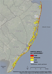 With only a month to undertake the mapping assessment, CRSSA Director, Richard Lathrop knew he would have to enlist a lot of help. Given the choice to sign onto the project, the 30 students of Introduction to Aerial Photo Interpretation didn't hesitate. Each student was given a 25 mi2 zone to assess and classify the severity of the physical impact using pre- and post-storm digital aerial photographic imagery collected by the US Geological Survey, NOAA and other sources. With the assistance of CRSSA staff, Lathrop compiled all the individual student work and quality controlled the results while GIS Coordinator John Bognar developed a series of maps.
The resulting report compiled by ALS documents hotspots of damage up and down the coast and will be used to prioritize state and federal habitat restoration efforts in the coming year. Click here to read the report and view the maps.